History
PAPPAS WAY AND THE SURROUNDING AREA ARE CONNECTED TO THE RICH HISTORY THAT CONTRIBUTED TO THE CITY OF BOSTON'S VIBRANCY, BOTH AT A LOCAL AND NATIONAL LEVEL.
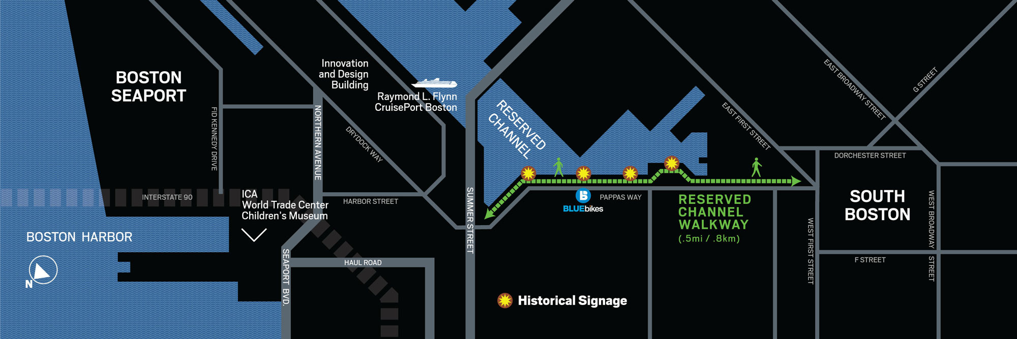
Newly installed historical signage scattered throughout the waterfront at Pappas Way tells the story of the site’s past in a thoughtful and informative way. We encourage visitors to walk along the Reserved Channel waterfront from Summer Street to East First Street to experience the physical signage containing even more details about the interesting history of Pappas Way and the surrounding area. See the map of signage locations here.
THE RESERVED CHANNEL IS CREATED
1860
THE SOUTH BOSTON FLATS PROJECT
Boston leaders became concerned about the trade that was being lost to New York and other large US ports. Extensive wharfing out narrowed shipping lanes and sediment was filling the harbor. The area between Boston’s waterfront and the South Boston peninsula was a large tidal mud zone known as the South Boston Flats, where low tide exposed sea grasses and small inlets. Since the early 1800s shoreline property owners had built wharves on the flats to reach deep water. In the 1860s a large seawall was planned to direct the force of the ebb tide into the shipping channel, helping to keep it clear. But property owners on the north shore did not want to participate in this project because they feared they would lose their rights to the tidal flats in front of their properties. So a channel was “reserved” to provide these owners with access to their flats.
1888
THE RESERVED CHANNEL IS CHALLENGED
The state legislature tried in 1877 to remove the Reserved Channel from Boston Harbor plans because of feared interference with railroad development. However, existing laws gave shoreline property owners rights to the flats 1,650 feet seaward from the high tide line. The Reserved Channel was restored to the South Boston Flats plan, and an agreement between the state and shoreline owners established the channel as a permanent fixture.
THE RESERVED CHANNEL INDUSTRY
1892
RESERVED CHANNEL RETRACTABLE BRIDGE
The first bridge over the Reserved Channel was constructed. Formerly known as the “L” Street or Summer Street Bridge, it served as a major route between downtown Boston and South Boston.
1898
L STREET POWER STATION
The L Street Power Station, a landmark feature on the Reserved Channel, went into service. It was built to replace the original downtown Boston Electric Light Company power station which was in the process of removal to make way for a downtown railroad terminal. The Reserved Channel location was chosen due to its access to water for cooling and coal deliveries by ship. It was soon acquired by Edison Electric Illuminating Company and went through several expansions and ownership changes, and final decommissioning, with plans for reuse and redevelopment on the horizon.
SOUTH BOSTON IS CHOSEN AS WORLD WAR I PORT
1912
BUILDING THE LARGEST DRY DOCK IN AMERICA
Work commenced on a large dry dock in the South Boston Flats. When the dry dock was completed in 1919, it was the largest dry dock in the United States, and remains today as the largest dry dock on the East Coast north of Virginia.
1917
BOSTON LOBBIES WASHINGTON
The US entry into World War I created a tremendous demand for the production, transportation and storage of war materials, the demands of which far exceeded the national capacity at that time. There was a national perception that New England railroads were poorly managed and in disrepair, and would be unable to serve the Port of Boston at the capacity needed. The Boston Chamber of Commerce realized the huge negative economic impact if other competing ports were upgraded for the war effort and Boston was excluded, and began to lobby Washington for Boston’s selection as a major war port. Around the same time, the three major New England railroads arranged to work together for the war effort. These efforts were successful and in January of 1918 South Boston was selected as a major embarkation point.
1918
THE SOUTH BOSTON NAVAL ANNEX
The US government purchased the new dry dock and surrounding land and established the South Boston Army Base. The South Boston Naval Annex was established two years later. For a time, the combined expanse of the open wharf and wharf shed for the Army Base was the longest in the United States.
CASTLE ISLAND IS CONNECTED
1920-1930
THE CONTAINER TERMINAL
When the Army supply base was constructed, the Reserved Channel was deepened and the dredgings dumped on the south side of the channel, which began to connect Marine Park with Castle Island. This area continued to be filled during the 1920s and 1930s using additional material dredged from Pleasure Bay. This continued until 1938 which created the land on which the Conley Container Terminal is now located.
1939
THE US ANTARCTIC EXPEDITION
Byrd’s Third Antarctic Expedition departed from the Army Base wharf on the Reserved Channel in November of 1939. This expedition was jointly sponsored by the United States Navy, State Department, Department of the Interior, and the Treasury. The objectives of the expedition as dictated by President Franklin D. Roosevelt were to establish two bases and conduct a variety of scientific observations. With international tensions on the rise, the two bases were evacuated with hopes they could be re-occupied in the future.
WORLD WAR II PORT ACTIVITY
1941-1945
US INVOLVEMENT IN WORLD WAR II
In World War II, the Army Base was used as the Boston Port of Embarkation, offering 550,000 square feet of storage space and handling millions of tons of cargo. 50,000 men and women worked around the clock at the Army Base and the neighboring Naval Annex, where they repaired American ships, as well as stored and distributed military supplies.
1943
E STREET ANNEX & PAPPAS WAY
During World War II the Navy began to fill the large area of flats at the end of the Reserved Channel east of E Street to create land on which to build barracks for sailors. Filling wasn’t completed until after the war was over, creating what came to be known as the E Street Annex. Pappas Way runs along the east side of the former E Street Annex.
BASE CLOSURES AND RENEWAL
1974
E STREET ANNEX & PAPPAS WAY
Activity at the Army Base and Naval Annex, once key anchors of the Reserved Channel, went into decline in the decades after WWll. The properties were used mainly for reserve storage, and many of the buildings and piers fell into disrepair. In 1974, Both the South Boston Army Base and Naval Annex were closed and acquired by the City of Boston to become part of the Boston Marine Industrial Park.
1984
CONTAINER TERMINAL
Boston’s ports experienced a decline that coincided with the development of the national rail system. With the advent of containerization, Boston sought to reestablish itself as a major port, and in 1971 built the Moran Container Terminal in Charlestown. As demand grew, a larger terminal on the Reserved Channel – located on the filled land between South Boston and Castle Island – was built and became operational in 1984 as the Paul W. Conley Container Terminal. This facility is the only full-service container terminal in New England, handling 2.3 million metric tons of cargo annually, connecting the region to Asia, Europe, and Latin America.
1986
CRUISEPORT
The Black Falcon Cruise Terminal opened in 1986 on the former South Boston Army Base. The facility is located in the renovated wharf shed adjacent to the former warehouse, and utilizes the original Army Base wharf on the Reserved Channel. In its first year 11,000 passengers embarked from the new terminal. In 2019, dozens of cruise lines, sailing to various destinations serviced over 400,000 passengers. In 2017, the terminal was renamed Flynn Cruiseport Boston in honor of Raymond Flynn, Mayor of Boston, 1984-93.
2003
NEW RESERVED CHANNEL BRIDGE
The original retractile drawbridge was replaced in 2003 with a fixed-span bridge. The bridge serves as a gateway to and from South Boston and Boston. The vertical clearance of the old span had to be increased to serve the needs of boaters and fishermen in the area. A fishing pier is incorporated into the design.
SPECIAL THANKS
Thank you to Brian Pearce at omloop design, local historian and historical archeologist Nancy S. Seasholes, Friends of the Harborwalk, Boston Harbor Now, and Massport for helping to bring this historical narrative to life.